Orbit is not just where a satellite happens to be. It is one of the first design choices that decides what the mission can do, how often it can do it, how much ground infrastructure it needs, how long signals take to arrive, and what kind of ending the spacecraft must plan for. A satellite in the wrong orbit may be a brilliant machine in the wrong neighborhood.
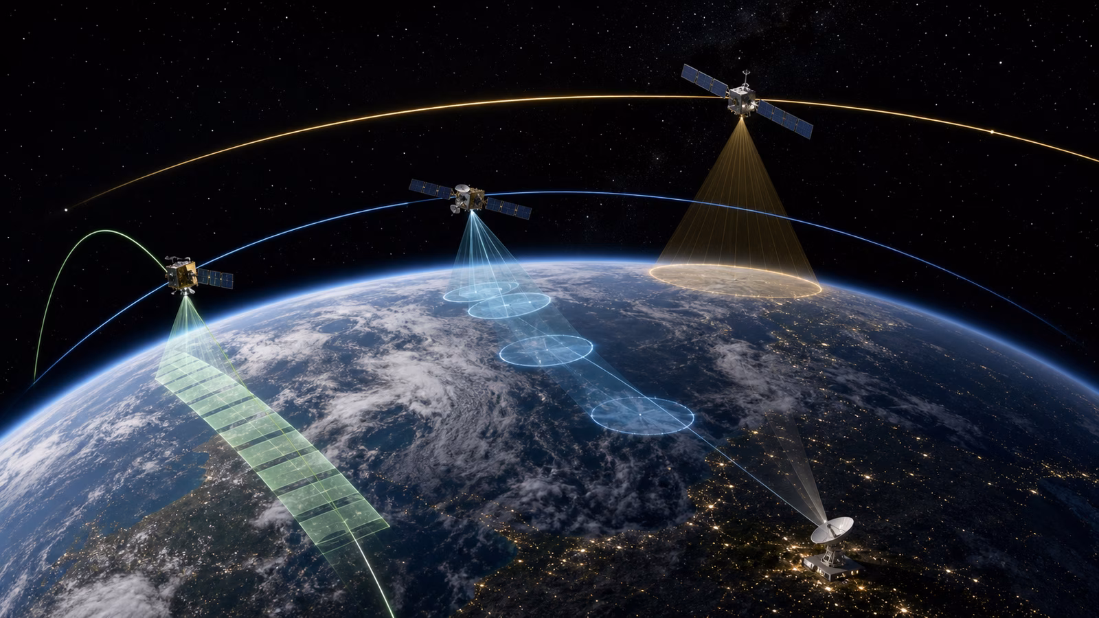
People often talk about space as though it were a single place above the atmosphere. In practice, useful space is layered. Low Earth orbit, medium Earth orbit, geostationary orbit, polar paths, sun-synchronous routes, highly elliptical orbits, and inclined constellations each solve different problems. The question is not simply how high a satellite flies. The question is what the satellite must see, who it must talk to, how quickly it must respond, how often it must revisit the same place, how much delay the service can tolerate, and how it will stay out of trouble while sharing the sky.
That is why orbital choice connects so many Spacefront topics. The delay described in Satellite Internet and Low-Earth Orbit Networks comes from distance. The repeated views in Earth Observation Is Everyday Infrastructure come from geometry and revisit time. The clocks in Satellite Navigation and Timing depend on carefully maintained orbital patterns. Even the earthside work in Ground Stations changes with the orbit, because a low satellite passes overhead quickly while a high one may appear almost fixed.
Low Orbit Is Close, Fast, and Demanding
Low Earth orbit is popular because it is close. Signals travel a shorter distance, which can reduce latency for communications. Cameras and sensors are closer to the ground, which can help with resolution. Launch vehicles can often place payloads there more easily than in higher orbits. For small satellites, Earth observation, technology demonstrations, science missions, and many broadband constellations, LEO is the practical workhorse.
The closeness comes with speed. A satellite in low orbit circles Earth quickly and does not stay above one customer, farm, city, or ground station for long. If one spacecraft must provide continuous service, it needs partners. That is why many LEO services are constellations rather than single satellites. As one satellite moves away, another comes into view. The service depends on choreography.
LEO also sits close enough to Earth that the upper atmosphere still matters. There is very little air, but not none. Atmospheric drag slowly changes the orbit, and solar activity can make the upper atmosphere expand, increasing drag. Operators may need stationkeeping maneuvers, and satellites that stop functioning may eventually reenter if they are low enough. This can be useful for debris mitigation, but it is not an excuse for careless design. A constellation with many satellites still needs tracking, collision avoidance, propulsion or drag-management plans, and a responsible end-of-life strategy.
This is the orbit where space can feel most like operations. Satellites move fast, contacts can be brief, traffic is busy, and replacement cycles matter. LEO is accessible, but it is not casual.
Polar and Sun-Synchronous Orbits Turn Motion Into Coverage
Not every low orbit follows the same path. A satellite in an equatorial orbit stays near the equator. A satellite in an inclined orbit reaches north and south only as far as its inclination allows. A polar orbit passes near the poles, and because Earth rotates underneath, the satellite can eventually see much of the planet.
That makes polar and near-polar orbits valuable for Earth observation. If the mission is to monitor forests, oceans, crops, ice, cities, fires, or storms, the spacecraft needs repeated access to many places. A polar path uses the planet’s rotation as part of the mission design. The satellite keeps moving in its orbital plane while Earth turns below, creating a sequence of ground tracks that cover different longitudes.
Sun-synchronous orbit is a special case that is especially useful for imaging and measurement. In a sun-synchronous orbit, the satellite crosses a given area at roughly the same local solar time on each pass. That consistency helps analysts compare images because lighting conditions are more predictable. A crop field, glacier, coast, or city is easier to compare across time when shadows and sun angle are not changing wildly from one observation to the next.
The tradeoff is that revisit is still limited by geometry and constellation size. A single satellite cannot stare at every location continuously. If a wildfire, flood, ship, or military event changes between passes, the system may miss some of the story. More satellites, wider swaths, radar sensors, and tasking systems can improve coverage, but the orbit remains part of the answer.
Medium Earth Orbit Is a Clockwork Layer
Medium Earth orbit sits above LEO and below geostationary altitude. It is less visible in everyday conversation, but it is essential for navigation systems. A navigation constellation needs satellites spread so that receivers on Earth can see several at once. The goal is not to hover over one city. The goal is a stable, global geometry that lets receivers turn precise timing into position.
MEO changes the trade space. A satellite is farther away than a LEO spacecraft, so the signal path is longer and the spacecraft sees a larger portion of Earth. It does not move across the local sky as quickly as a low satellite. For positioning, navigation, and timing, that larger geometry is useful. A receiver can listen to multiple satellites from different parts of the sky and solve for location and time.
The mission design burden moves toward clock quality, orbital stability, ground monitoring, signal integrity, and long-term maintenance. Navigation satellites are not useful because they are dramatic. They are useful because they keep being predictably where the system says they are, broadcasting timing signals that receivers can trust.
That trust depends on the whole architecture. The orbit, the satellite clock, the ground control segment, the signal design, and the receiver all belong together. MEO is not simply a height. It is a working layer for shared time and location.
Geostationary Orbit Trades Distance for Persistence
Geostationary orbit is much higher. A satellite there circles Earth at the same rate that Earth rotates, so from the ground it appears to hang over one longitude above the equator. This is why a fixed dish can point at one spot in the sky and keep using the same satellite.
That persistence is powerful. Weather satellites can watch the same hemisphere continuously. Broadcast and communications satellites can serve wide regions. Some relay missions can maintain long contacts. For many applications, the ability to remain in view matters more than the delay created by distance.
The cost is that the signal must travel a long way. For interactive internet, voice, gaming, or remote control, that delay can be noticeable. A geostationary satellite also has weaker visibility at high latitudes because it sits over the equator from the user’s perspective. The farther north or south the user is, the lower the satellite appears in the sky, and terrain or buildings can become more difficult.
Geostationary orbit is also a limited and valuable neighborhood. Satellites must be spaced and coordinated to avoid interference and maintain safe operations. At end of life, they are typically moved away from the protected operating region if they have enough capability left. The orbit feels fixed from Earth, but it still demands stewardship.
Highly Elliptical Orbits Solve Awkward Geography
Some missions use highly elliptical orbits, where the satellite comes close to Earth at one part of its path and travels far away at another. Near the high point, called apogee, the satellite moves more slowly from the ground’s perspective and can spend a long time over high-latitude regions. This can be useful when geostationary satellites sit too low in the sky for polar or near-polar users.
The idea is not that an elliptical orbit is better in general. It is better for particular coverage problems. If the service must spend time looking at or communicating with northern regions, the geometry may favor an orbit that lingers there. But elliptical orbits can complicate operations, radiation exposure, ground tracking, and mission planning. They are another reminder that orbit is a tool chosen for a job, not a prestige category.
Ground Tracks, Revisit, and the Reader’s Practical Question
One of the most useful terms in orbital thinking is ground track. This is the path the satellite appears to trace over Earth’s surface. A ground track tells you what the satellite can see or serve and when. For Earth observation, it shapes revisit time. For a ground station, it shapes contact windows. For a communications constellation, it shapes handovers. For launch planning, it shapes where the rocket can safely fly and where the satellite must be inserted, which is why Launch Windows and Mission Timing is really an orbital geometry story as much as a countdown story.
Revisit time is not the same as usefulness. A satellite may pass over a location often but at the wrong time of day, from the wrong angle, through clouds, or without the right sensor. A communications satellite may cover a place but not provide enough capacity. A navigation satellite may be visible but poorly placed in the sky for precise positioning. Orbit gives opportunity. Mission design turns opportunity into service.
This is also where Satellite Operations After Launch and Space Debris and Orbital Traffic enter the picture. The chosen orbit determines how crowded the neighborhood may be, how collision warnings are handled, how much drag affects the spacecraft, how much propellant stationkeeping may consume, and what end-of-life path is realistic. A mission cannot separate the useful middle of its life from the orbital consequences of its beginning and ending.
One Orbit Never Wins Everywhere
There is no universal best orbit. LEO can lower latency and improve imaging, but it requires motion management and often many satellites. MEO supports navigation geometry and timing, but it is farther away and demands stable long-term operations. Geostationary orbit provides persistent regional views, but distance creates delay and high-latitude coverage limits. Polar and sun-synchronous paths help observe the whole planet under repeatable conditions, but they cannot watch every event continuously. Highly elliptical orbits can serve special geography, but they bring their own complexity.
The practical habit is to ask what the mission is trying to deliver. A rural broadband service, a crop-monitoring satellite, a weather watcher, a navigation constellation, a television relay, a polar communications system, and a lunar support network do not want the same orbit. They want the orbit that best matches their service, physics, budget, ground segment, regulatory needs, and end-of-life plan.
Once you see orbit as infrastructure, space becomes easier to read. A satellite’s altitude is not a trivia fact. Its inclination is not a diagram detail. Its ground track is not a classroom abstraction. These choices decide who gets coverage, how fast data moves, how often observations repeat, what the ground system must do, and how responsibly the mission can leave the neighborhood when the work is done.
The map of space is therefore not only a map of places. It is a map of tradeoffs. Every useful satellite lives inside one of those tradeoffs, and every mature space service learns to explain why it chose the path it did.


